William Porter & The Driffield Navigation
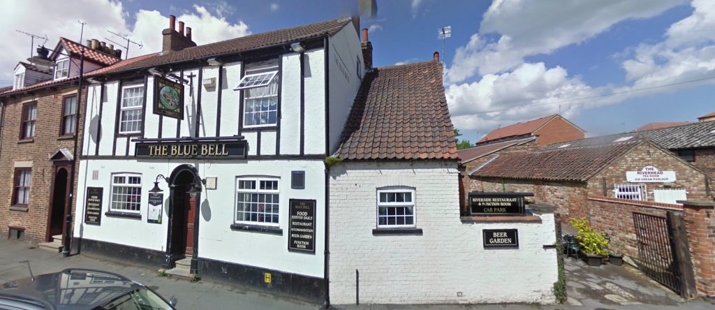
The Blue Bell Inn sits opposite River Head, at the northern end of the Driffield Navigation. The landlord in the mid 18th century was our 6th Great Grandfather William PORTER (1714-1790). William was one of several Gentlemen, Freeholders, Tradesmen, and others, of the County of Yorkshire who petitioned Parliament in 1767 to pass legislation to build a navigable waterway from Driffield to the River Hull.
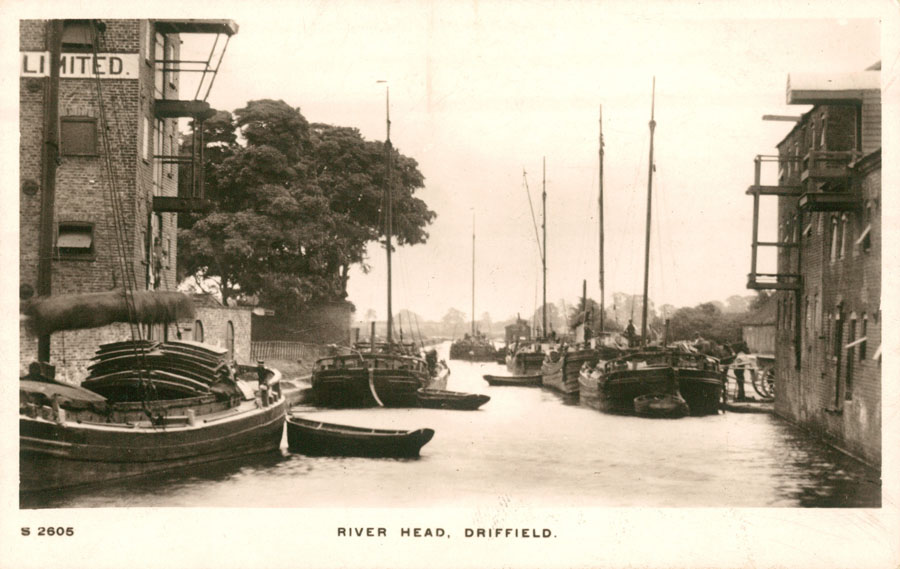
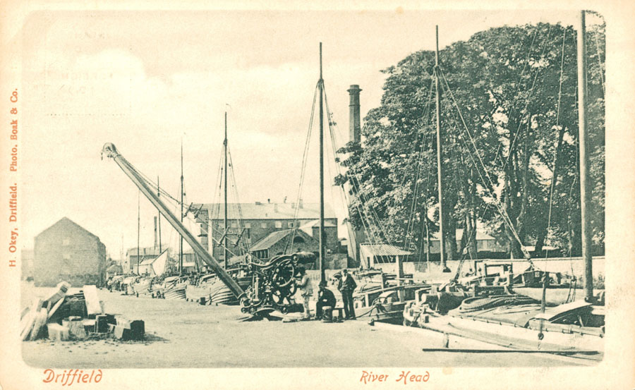
The result was the Driffield Navigation, an 11-mile waterway from the River Humber, through the heart of the Holderness Plain, to the market town of Driffield, East Riding of Yorkshire. The northern section of it is a waterway, and the southern section is part of the River Hull.
In addition to being a landlord, William Porter was also a corn factor (dealer) with a desire to transport his products more cost effectively to the River Humber, the markets of Kingston upon Hull, and beyond. William was a driving force of the campaign, attending meetings in Malton and Driffield, giving evidence before the committee on behalf of the project promoters, and defending the Driffield Navigation against competing proposals. The Bill received Royal Assent on 20 May 1767 and the Act named almost 100 commissioners — local gentry and merchants — any seven of whom were empowered to borrow money, with which to fund the construction of the waterway.
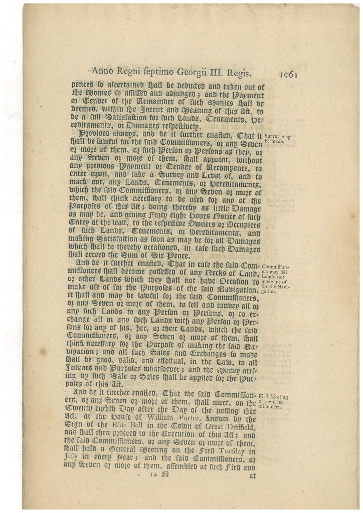
… And be it further enacted, That the said Commissioners, or any Seven or more of them, shall meet, on the Twenty eighth Day after the Day of the passing this Act, at the house of William Porter, known by the Sign of the Blue Bell in the Town of Great Driffield, and shall then proceed to the Execution of this Act; and the said Commissioners, or any Seven or more of them, shall hold a General Meeting on the first Tuesday in July in every Year; and the said Commissioners, or any Seven or of them, assembled at such first and…
ACTS OF PARLIAMENT: 1 – Canals and Navigable Waterways Acts of Parliament: — 6 – Driffield Navigation Act, Page 12
The commissioners appointed renowned civil engineer, John Grundy, as engineer-in-charge. Curiously, when the commissioners were struggling to find the right surveyor, William’s son Richard Porter took on the job at £50 a year. After just six weeks John Grundy had sourced a suitable replacement. Later on Richard undertook a great deal of the navigation’s carpentry work.
Oak was being delivered by Porter from November 1767 at 3s. a cubic foot, with 2d. a foot extra allowed him ‘in case the Roads and Carriage grow bad’. Carpentry, piling, etc., was let to Thomas Nalton and Richard Porter. They contracted for the timberwork of the first lock (at Snakeholme) at £73 and for the second lock (Wansford) at £57 Ss., £9 7s. 6d. of which was for laying the lock’s floor and applying tar and hair to it.
The Inland Waterways of East Yorkshire 1700-1900 by Baron F Duckham
The Driffield Navigation fully opened in 1770, although improvement works persisted throughout the 18th and 19th century. The Porter family benefitted greatly from the more cost effective navigation. William’s sons William PORTER & Richard Porter built a four storey mill with basement making textiles and carpets in Skerne Road, Driffield.
However the waterway was not the optimistically profitable venture the investors had been promised. The expected dividends of 5% did not materialise, but dividends were paid in most years after 1774, starting at 1.5% and rising to 4% by 1790. By 1784, the navigation was making enough profit for the commissioners to build a warehouse and granary at Driffield.
The Driffield Navigation Act allowed horse haling-ways (towpaths) to be made and permitted the following (maximum) tolls up to Driffield in 1770:
| Product | Cost | Quantity |
|---|---|---|
| Wheat, rye, beans, peas, rapeseed | 6d | qur (quarter ton / 40 stone / 560lb) |
| Malt, oats, barley, etc. | 4d | qur (quarter ton / 40 stone / 560lb) |
| Flour, etc. | 4d | sack (20 stone / 280lb) |
| Coal, etc. | 3s. 6d. | chaldron (36 bushels / 5940lb) |
| Bricks, stone, tiles, building lime | 3s. 6d. | ton (2240lb) |
| ‘Merchandise’, etc. | 4s. 0d. | ton (2240lb) |

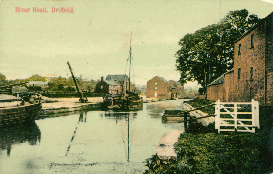
Traffic steadily increased and the Driffield Navigation provided service through the 19th Century, complimented by the railway from 1846, whose station was built almost adjacent to Riverhead. By the 1930s the navigation was serving minimal traffic and fell into disrepair until organizations like the Driffield Navigation Trust took it upon themselves to restore the waterway for pleasure craft and hikers rambling along the horse paths.
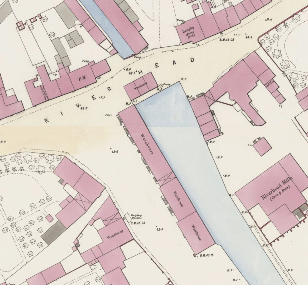
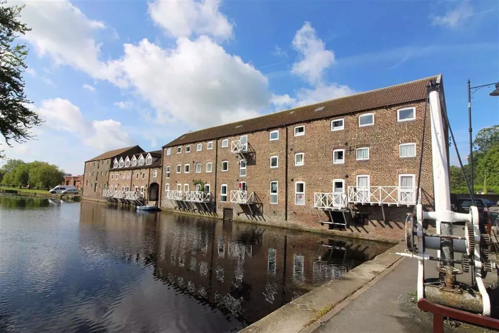
The mills and warehouses of River Head on the 1891 map above have been converted into luxury flats as seen below on this recent property listing. The Blue Bell Inn is annotated with P.H. to denote its status as a Public House on the north side of River Head.
Contradictory history lists the driver behind the Driffield Navigation as Thomas Porter, a name which has since propagated through many websites with no source referenced. The East Riding of Yorkshire Archives provided access to the specific 1767 Acts of Parliament (see above) and confirmed that William Porter was the landlord of the Blue Bell in Great Driffield where the commissioners of the Driffield Navigation gathered. The only reference to Thomas Porter in relation to the waterway was in 1822, someone with that name kept the lockhouse at Hempholme.
Family Tree
- William PORTER (1714-1790) & Joye (~1740-?)
- William PORTER (1758-1833) & Ann WHITEHEAD (1757-1834)
- Elizabeth PORTER (1790-1870) & George SHEPHERDSON (1793-1867)
- Ann SHEPHERDSON (1820-1909) & George SMITH (1816-1892)
- Elizabeth SMITH (1849-1907) & Robert THOMPSON (1839-1896)
- William THOMPSON (1891-1964) & Clara Eva BAKER (1893-1962)
- Winifred May THOMPSON (1920-1977) & Charles Reginald BAINBRIDGE (1915-1994)
- Our direct line…
- Winifred May THOMPSON (1920-1977) & Charles Reginald BAINBRIDGE (1915-1994)
- William THOMPSON (1891-1964) & Clara Eva BAKER (1893-1962)
- Elizabeth SMITH (1849-1907) & Robert THOMPSON (1839-1896)
- Ann SHEPHERDSON (1820-1909) & George SMITH (1816-1892)
- Elizabeth PORTER (1790-1870) & George SHEPHERDSON (1793-1867)
- William PORTER (1758-1833) & Ann WHITEHEAD (1757-1834)
References
- Volume containing Drainage and Navigation Acts, etc, The National Archives
- Driffield Navigation Commissioners, The National Archives
- Driffield Navigation Act, East Riding of Yorkshire Archives
- William Porter, Corn Factor, 26 February 1767, Journals of the House of Commons, Volume 31, Google Books
- The Inland Waterways of East Yorkshire 1700-1900 by Baron F Duckham, East Yorkshire Local History Society 1973
- River Head, Driffield, What Was Here? East Riding Archive
- John Grundy Jr., Civil Engineer, Wikipedia
- Driffield Navigation, Wikipedia
- Driffield Navigation Trust
- What was here? East Riding Archives
- Grade II Listed Hand-operated swivel crane, Riverhead, Driffield, Historic England
- Grade II Listed 2-4 Riverhead, Driffield, Historic England (not Blue Bell Inn at 5 Riverhead)
- Grade II Listed Warehouse, Riverhead Court, Driffield, Historic England
- Grade II Listed Mortimer’s Warehouse, River Head, Driffield, Historic England
- Grade II Listed E B Bradshaw & Sons Ltd., Riverhead Mill, Driffield, Historic England
- Grade II Listed Hand-operated swivel crane, Riverhead, Driffield, 120 meters south of Mortimer’s Warehouse, Historic England
- Grade II Listed Town Lock, Driffield Navigation, Driffield, Historic England
- Quarter, Imperial Measurement, Wikipedia
- Ordnance Survey, Yorkshire Sheet 161, Surveyed: 1850 to 1851, Published: 1855. NLS.uk
- Ordnance Survey, Great Driffield – Yorkshire CLXI.12.18, Surveyed: 1891, Published: 1892. NLS.uk
- Ordnance Survey, Great Driffield – Yorkshire CLXI.12.23, Surveyed: 1891, Published: 1892. NLS.uk
- For Sale – The Blue Bell Riverhead Driffield, Topham Larard
- River Head 2016 – Driffield Navigation HD, YouTube
- Driffield History Group, Facebook
- Driffield, Yorkshire – History, tourist information, and nearby accommodation, by David Ross, Britain Express
- Driffield Navigation, Inland Waterways Association
- Driffield Navigation Trail, Visit East Yorkshire


Revised article with scan from Acts of Parliament supplied by East Riding of Yorkshire Archive confirming commissioners gathered at the Blue Bell in Great Driffield owned by landlord William PORTER.