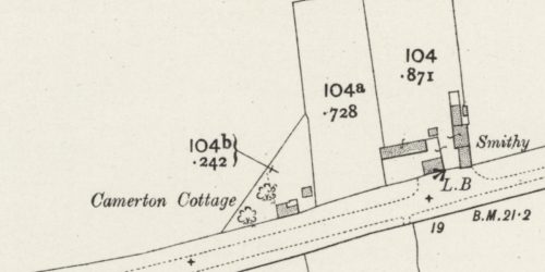
Storwood, Baron de Ros, & Hall Hills Hall
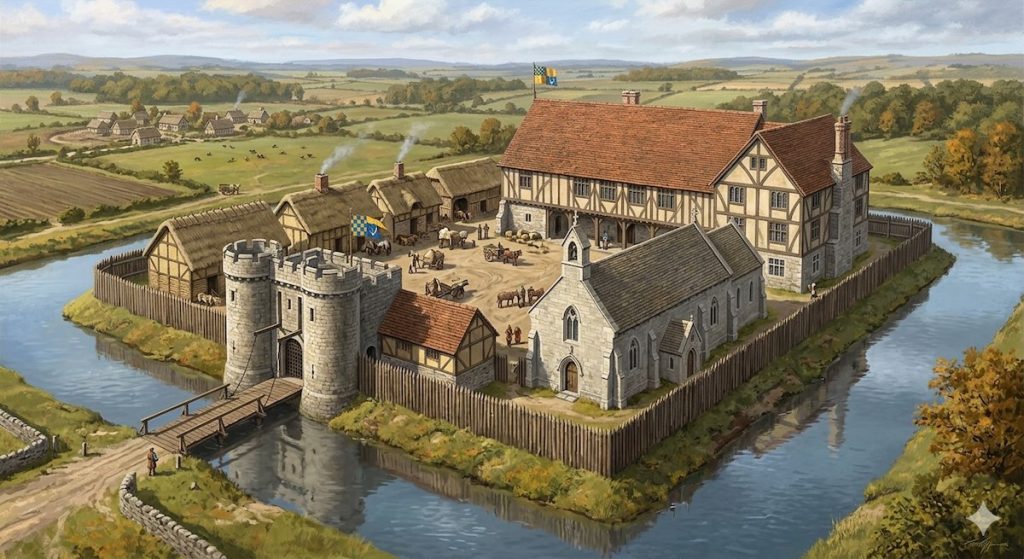
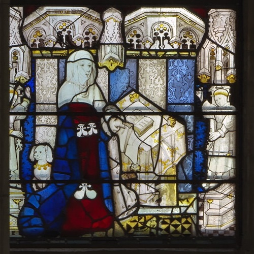
The Hall of Hall Hills was the mediaeval manorial complex at Storwood, controlled by the feudal overlordship of Ralph de Mortimer from 1086, and remained in the family until 1425. The site, at the south end of the hamlet, is still surrounded by a prominent moat and was one of the manors of the Baron de Ros of Helmsley, including Robert de Ros, Magna Carta baron signatory. The manor was described as ruinous by 1343 but may have been reconstituted with a chapel, for in 1414 Beatrice de Ros left £401 for a chaplain to celebrate mass in the Storwood chapel.
Location, Location, Location
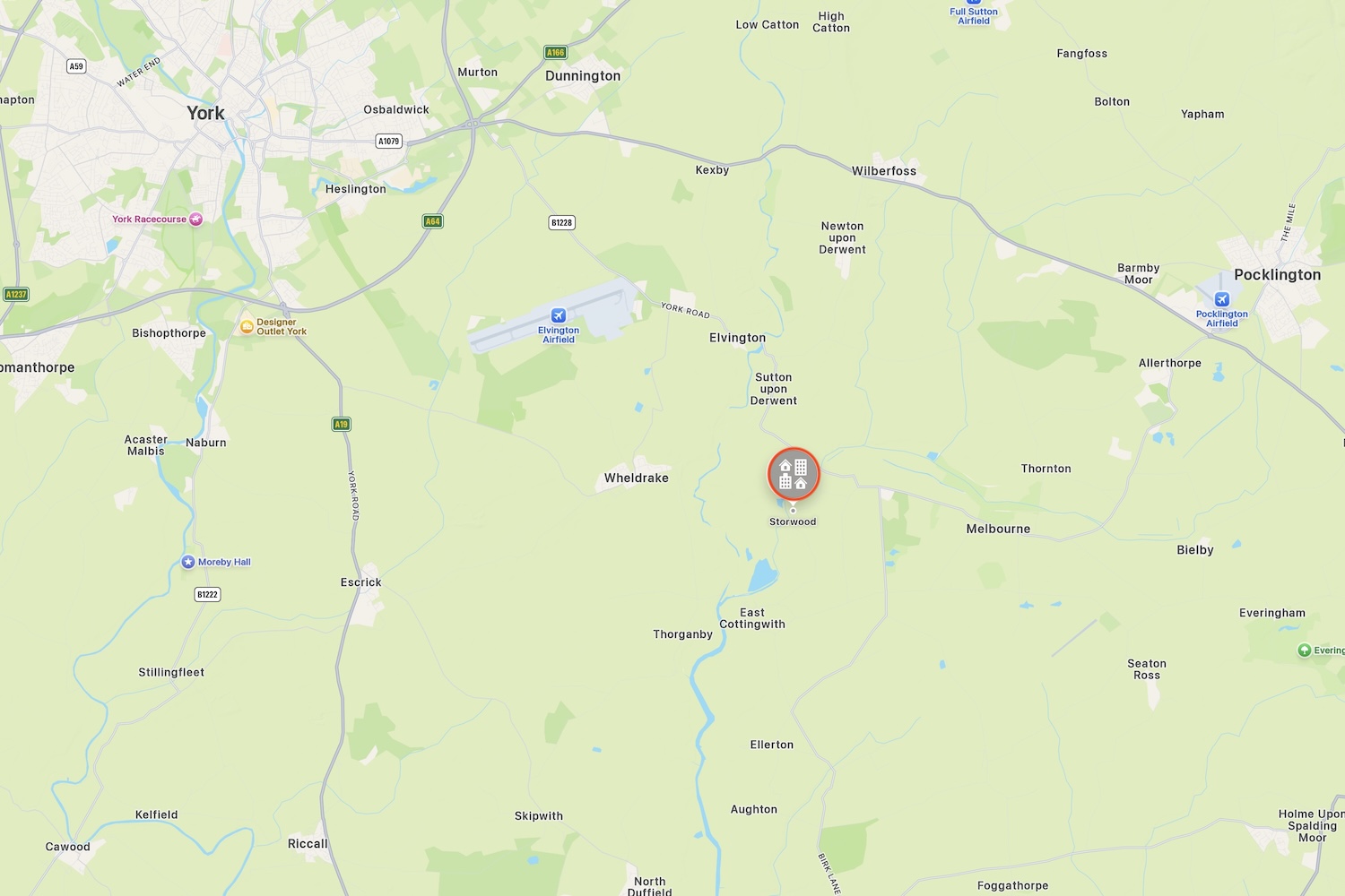
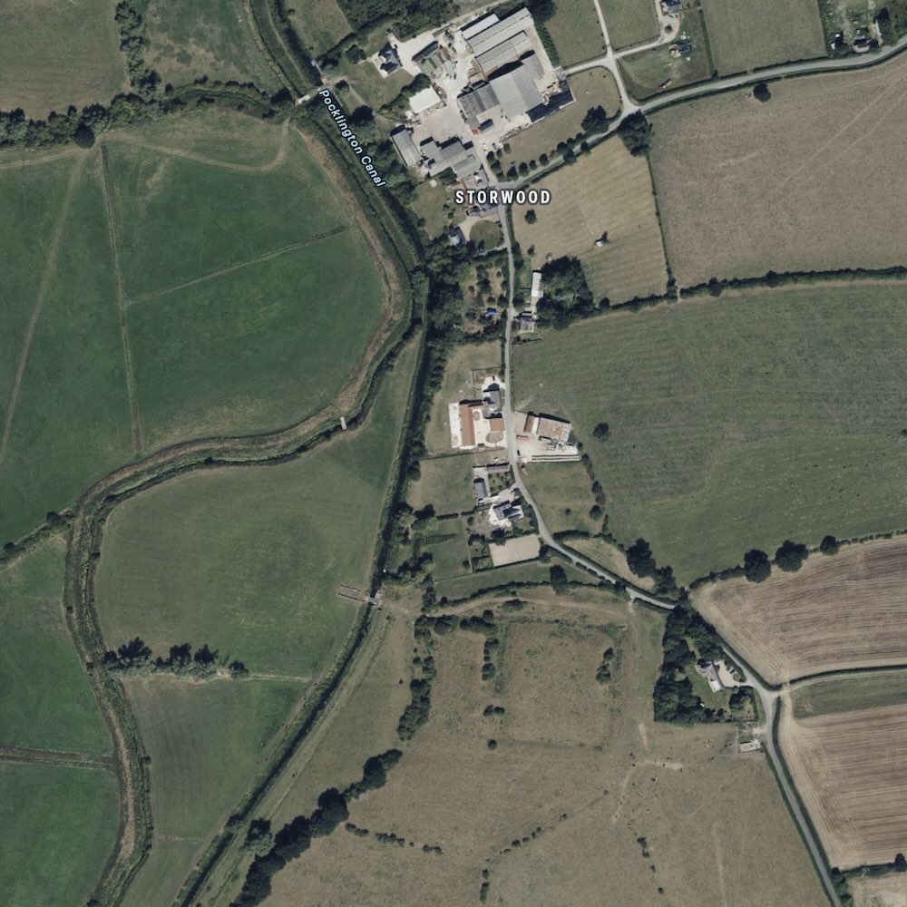
Hall Hills is located in the hamlet of Storwood, in the parish of East Cottingwith,3 approximately 6 miles south-west of Pocklington, and lies south of the B1228 on the south bank of the Pocklington Canal. The name Storwood derives from the Old Norse storðþveit meaning either ‘plantation clearing’ or ‘brushwood clearing.’4 Documented since 1086 in the Domesday Book, the history of this hamlet belies its diminutive size.
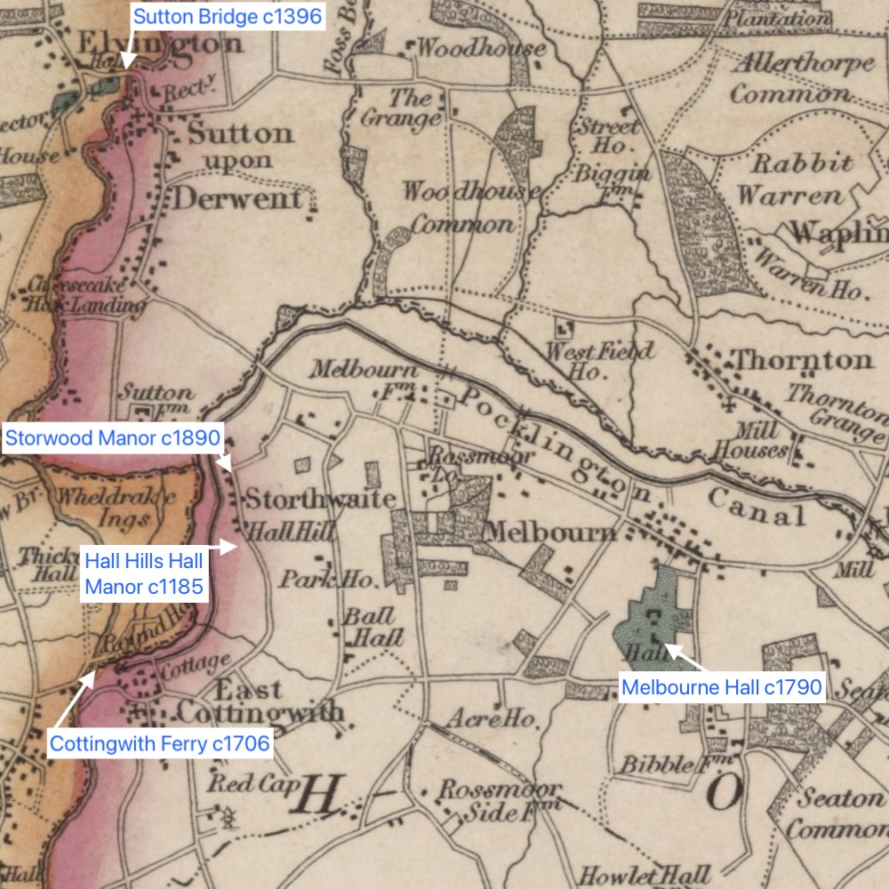
The moat and building platform have been labeled on maps as Hall Hills and the site of a Hall, hence Hall Hills Hall. The hamlet of Storwood, formerly Storthwaite, Stothwood, and various other spellings, has been documented as far back as the Domesday Book in 1086 as the vill of ‘Chetelstorp’6, although the name as we know it begins in the 12th Century. The presumed manorial complex was likely constructed in the late 11th Century or early 12th Century on dry ground overlooking the river Derwent with extensive Norman water engineering.
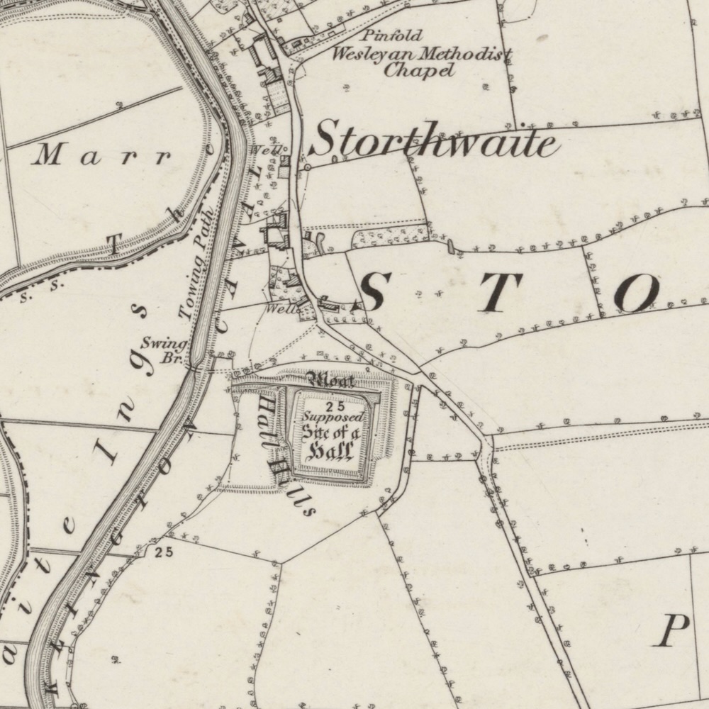
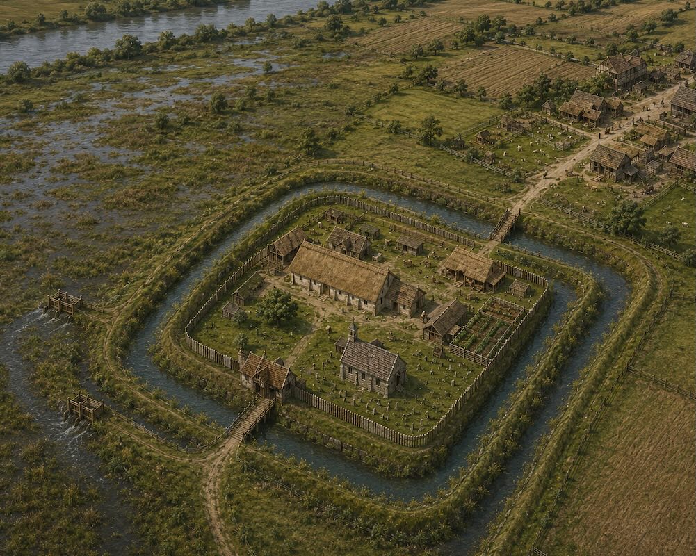
In medieval times, the River Derwent and its flood plains would have aligned with the extensive earthworks and water management systems. However the path of the River Derwent8 was diverted away from Storwood in 1702 to allow for ease of navigation and the Pocklington Canal cut through the lower earthworks of Hall Hills, 1816-18189. The closest River Derwent crossing was a ferry service from the neighbouring village, East Cottingwith to West Cottingwith recorded as early as 1706,10 shortly after the river course was changed.
Reasons for Designation
Historic England11 states ~6,000 moated sites are known in England, the majority built between 1250-1350 in central and eastern parts of England. Despite limited disturbance to this moat’s drainage channels, the Hall Hills site south of White House survives well. The island is unencumbered by modern building and will retain evidence of the buildings which occupied it:
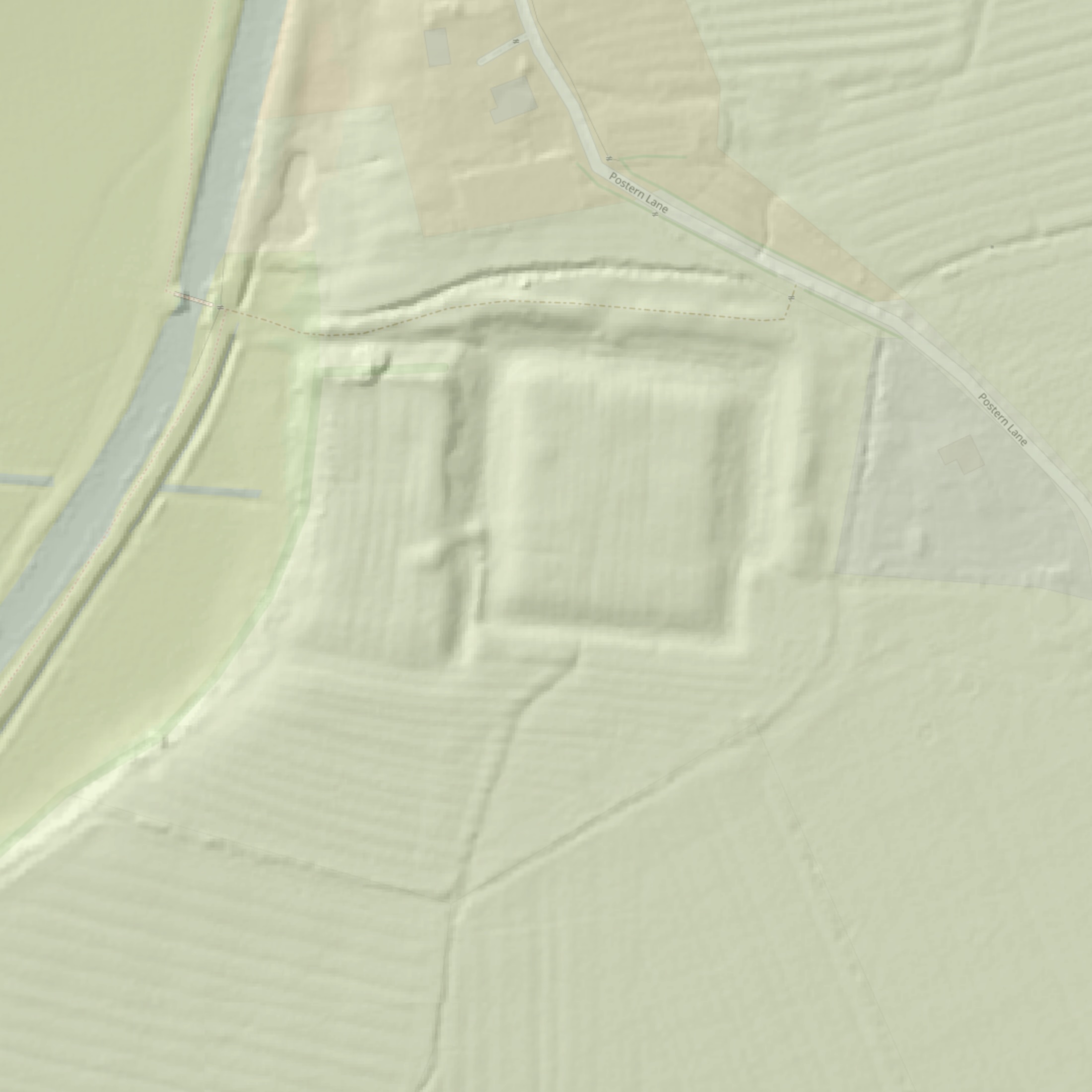
A large moated site to the south of the village of Storwood; it is situated on ground above the Pocklington Canal and the old course of the River Derwent. It includes a sub-rectangular island 90m long, north-south, and 70m wide, east-west, which is defined by a dry moat which is between 10m and 25m wide and between 1.5m and 3m deep.
Immediately external to the northern and eastern arms of the moat there is an earthen bank 7m wide and up to 1.5m high. An earthen bank is also visible immediately external to the moat’s western arm; it is between 5m and 9m wide and is up to 1m high. Water-management features extend from the south-western and north-western corners of the moat, both features are overflow channels designed to carry water from the moat to the river course. Excess water was carried away by these two channels which ran off to the west from the moat’s western arm. The channel which runs from the north-west corner is 10m wide and up to 2m deep. Where this channel connects with the moat it has been partially dammed with an earth bank; the 2m wide gap in this dam would have held wooden sluices to control the water.
There are flanking earthen banks 5m wide and up to 1m high immediately external to the drainage channels. The features at the south-western corner are more complex than those to the north. Here the western arm of the moat has been subdivided by an earthen bank 15m long, 4m wide and 0.5m high. This connects with a large bank 6m wide and 5m long which extends into the moat from the west and which is believed to have been a bridge platform affording access to the island.
Close to the bridge platform there is a 1m wide break in the dividing earthen bank which would have held wooden sluice gates. The section of the moat to the west of the dividing bank connects with a heavily silted channel between 8m and 10m wide and up to 0.5m deep which runs westwards toward the old river course. Both drainage channels have been truncated to the west by works associated with the construction of the Pocklington canal. A heavily silted channel 0.3m wide and 0.15m deep runs into the southern arm of the moat; this channel is interpreted as a post-medieval field drain as it connects to other drainage features and boundary ditches.
The monument is believed to have belonged to the De Roos family who built Helmsley Castle and held property right across Yorkshire.
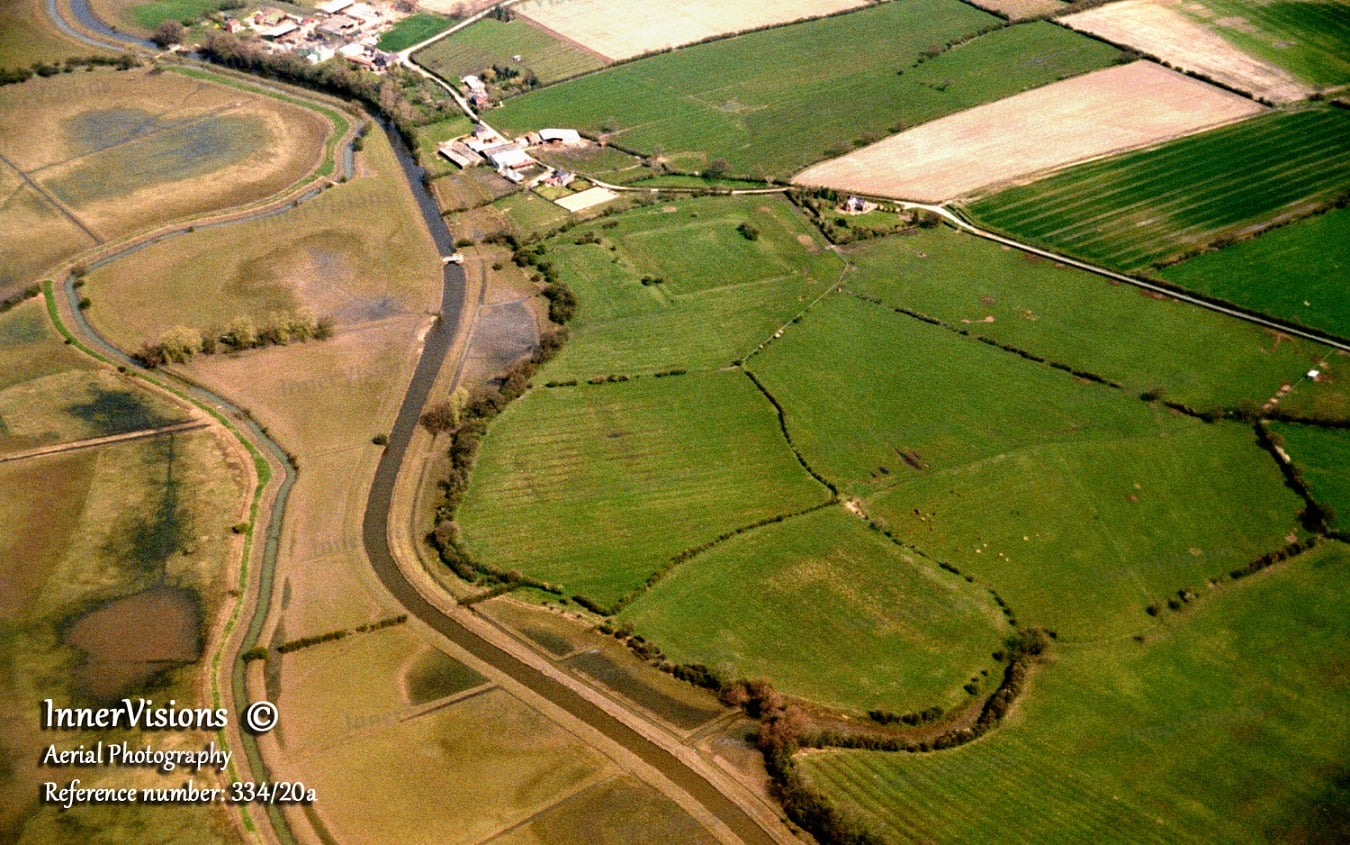
The aerial view is clearer when viewed from an angle in the Inner Visions Aerial Photography in the centre top of the close-up photograph below as opposed to the standard satellite imagery of Apple Maps.
Moated site and water-management features south of White House, Scheduled Monument 1007974, 22 July 1964, Historic England12
Storwood’s Manors & Melbourne Hall
The location of the manor has changed over time, not only within Storwood but even a neighboring village. The initial Hall Hills location was supplanted by Melbourne Hall by 1790. Despite the construction of the new Storwood Manor in the late 19th Century, the center of the estate did not return to Storwood. The open questions remain about when the original Hall Hills Hall was abandoned and stripped of any remaining building materials? 1343 when the manor was described as ruinous? Post 1415 after the death of Beatrice Stafford, dowager Baroness Ros? It is recorded by 1690 that the owner, John Bradley, lived in Storwood, but not in the manorial complex.
The LIDAR clearly shows the faint traces of medieval ridge and furrow ploughing in the parallel lines on the earthworks and surrounding lands. Hopefully the medieval ploughing has not disturbed the underlying archaeology. The presence of ridge and furrow ploughing does demonstrate the building platform was derelict, cleared of building rubble, and returned to agriculture before the enclosure act of 1772. The land has been pasture for the past 50 years and I have no knowledge of the land being ploughed in modern times.
Family Tree of Baron de Ros

Following the Norman Conquest, William the Conqueror granted the lands to Ralph de Mortimer, making the Mortimer family the Tenants-in-chief directly under the King. Instead of managing the estate directly, the Mortimers subinfeudated the land.
By the early 13th century, the de Ros family acquired the tenancy in demesne17 and they held it by “knight service” under the Mortimers. The construction of the Hall Hills Hall manorial complex may have been started by either family.
The de Ros family was on the rise and titles soon followed. Baron de Ros (or Roos) of Helmsley is the premier baron in the Peerage of England, created in 1288 for William de Ros (c1255-1316). Premier baron is a designation and status awarded to the holder of the most ancient extant barony of the Peerage of England18.
The de Ros family shares a storied lineage linked by tradition to the early Kings of Scotland, while their title, Baron de Ros, stands categorically as England’s oldest surviving peerage created by writ. Now held by the 27th Baron, the title’s remarkable 800-year endurance stems from strategic matrimonial alliances and, crucially, the unique legal mechanism of abeyance, which allows the barony to pass through female lines when male heirs are lacking.
Abeyance describes a state of temporary dormancy or suspension. In law, it can refer to a situation where the ownership of property, titles, or office is not currently vested in any specific person, but is awaiting the appearance or determination of the rightful owner. This typically applies to future estates that have not yet vested, and may never vest.
Abeyance, Wikipedia.org
Historic Timeline
The following timeline has been extracted from Pocklington History, the Hemingbrough Chapter and the Thornton chapter of A History of the County of York East Riding: Volume 3, Ouse and Derwent Wapentake, and Part of Harthill Wapentake. Originally published by Victoria County History, London, 1976.19
| Year | Owner/Resident | Notes |
| 1066 | Eddiva aka Edith the Fair20 | 6 carucates21 in Melbourne and another carucate in ‘Chetelstorp’ aka Storwood. Eddiva the Fair (1025-1086) was the first wife of the last Anglo Saxon King of England, Harold Godwinson (1022-1066) |
| 1086 | Ranulph de Mortimer | The 6-carucate estate in Thornton which Eddiva held in 1066 had passed to Ralph de Mortimer by 1086, and its overlordship remained with the Mortimers until 1425. • Ralph / Ranulph de Mortimer (c1070-1104) • 1st son of Ranulph was Hugh de Mortimer, whose descendants became the Earls of March |
| ~1120 | Peter (Pier) de Ros (1087-1128), who was linked with the Mortimer family by marriage, gave two carucates of land to St. Mary’s Abbey, York.22 (12th century) First marriage of Peter de Ros to de Mortimer. He either had a brief, unnamed first wife from the Mortimer family, or one of his close female relatives married into Ralph de Mortimer’s lineage. Second marriage to Adeline Espec, the youngest sister and co-heiress of the powerful northern baron Walter Espec of Helmsley. It was through this marriage to Adeline that the de Ros family famously inherited their vast wealth and their primary seat at Helmsley Castle. | |
| ~1135 | Warter Priory (1132-1536) had a hermitage23 at Storwood in the 12th century.24 The hermit would have been a religious hermit (eremite) or hermit-canon operating under the institutional oversight of the Augustinian canons25 of Warter Priory. King Henry I was involved in the conveyance of Goathland hermitage to Whitby Abbey and similar conveyances by other patrons of hermitages at Storwood, Spaldingholme, and Sproxton. Assuming that is correct, then the Storwood hermitage would have to be established during the king’s reign, 1100-1135, and after the establishment of Warter Priory in 1132. A 12th-century hermitage in this region of East Yorkshire relied heavily on local timber, mud, and turf. The manorial complex with hermit could have included a small rectangular chapel/oratory. It likely featured a low stone foundation supporting a timber-framed frame (wattle-and-daub) with a steeply pitched thatched roof. Inside was a simple stone altar and a single window facing east toward the dawn prayers. The hermit lived in a small attached or standalone hut. The interior was incredibly sparse, containing a straw palette bed on a low wooden shelf, a simple wooden stool, a hearth for warmth, and basic pottery for water and gruel. The hermit would maintain a small garden plot to remain self-sufficient. | |
| 1215 | Robert de Ros, Magna Carta Baron | Sir Robert de Ros (1160-1227)26 was an Anglo-Norman feudal baron and held land in Melbourne and Storwood in the early 13th century by a Vescy grant. Magna Carta baron, Robert de Ros, had deep local roots. His mother, Rohese Trussebut, was born at Warter, and the Trussebuts were long standing owners of Warter and the founders of Warter Priory. De Ros inherited the Trussebut estates from his grandfather and had a manor house at Storwood.27 |
| 1243 | William de Ros | Robert de Ros’ son William de Ros (c1196-1265), Lord of Helmsley28, was an English noble and had a knight’s fee there and elsewhere in 1243 |
| ~1275 | Vescy Family | The Vescy family were mesne lords29 in the late 13th century. |
| 1285 | Robert de Ros | At William de Ros death 1265 his son Robert de Ros of Helmsley (1237-1285)30 held STORWOOD manor, and the estate, comprising 6 carucates in Melbourne and Storwood in 1289-90. The Ros manor-house at Storwood was mentioned in 1285. By the 13th century much land in the townships of Melbourne and Storwood had been reclaimed, although extensive wastes remained. In 1285 the value of the manor, about £28, was equally divided between Storwood and Melbourne. As well as the manor-house and park, valued at £3 10s. a year, there were 80 a. of arable land in demesne at Storwood, and a turbary31 worth,£6 13s. 4d. Twelve cottagers, who had fishing rights, paid over £1 in rents. There were also 12 a. of meadow, presumably in demesne, and a mill. The turbary lay in the waste already known as Landrikmose. |
| 1327 | John de Ros | John de Ros was the 3rd son of Robert de Ros after • 1st son: William de Ros, 1st Baron de Ros • 2nd son: Sir Robert de Ros of Gedney, Lincolnshire, who married Erneburge. A large part of the Turnham family’s estate in the township was separate from Cliffe manor, known as the manor of Turnham Hall. It was conveyed by Eleanor de Mauley, along with her half of Cliffe Manor, to Hugh Despenser in 1323, but the Despensers’ estates were confiscated by the Crown in 1326 and the manor was granted to John de Ros in 1327. It descended like Storwood until shortly before the death of William Cecil, Lord Ros, in 1618.32 |
| 1343 | William, 2nd Baron Ros | Margery, widow of William Ros (1285-1343), 2nd Baron Ros of Helmsley33, held the manor as dower until her death in 1363. The Ros manor-house at Storwood was described as ruinous in 1343. |
| 1343-1363 | Margery De Ros | Margery De Ros née Badlesmere (1304-1363)34, widow of William, Lord Ros, held the manor as dower until her death in 1363. In 1343 The manor was worth about £30. The demesne comprised 80 a. of poor land, 14 a. of meadow, 12 a of poor-quality meadow called Oddland ing, and a close at Melbourne. The park was valued for herbage and there was a small wood. The herbage and turves of the moor were worth £5, unless there was flooding, and a fishery ‘in the marsh’ produced 6d. in summer. At Storwood the tenants-at-will owed about £1 15s. Court profits were only 3s. 4d. because of the tenants’ poverty. |
| 1384 – 1415 | Thomas, 4th Baron Ros & Beatrice Stafford | Thomas Ros (1335-1384), 4th Baron Ros of Helmsley35 , held the estate jointly with his wife Beatrice Stafford (c1341-1415), who died seised of it in 1415. The manorial complex may have contained a chapel, for in 1414 Beatrice de Ros left £20 for a chaplain to celebrate mass in Storwood chapel. 1st son: John Ros, 5th Baron Ros (c1364-1393)36 2nd son: William Ros, 6th Baron Ros (1370-1414) inherited his father’s feudal barony and estates37 2 more sons & 2 daughters |
| 1421 | The manor was valued at about, £38 a year in 1421. In addition to the turbary and the park, which were worth £15 a year, there were 80 acres of arable and 80 acres of meadow in demesne; the rents of free tenants amounted to £1 10s. and those of 20 tenants-at-will to £10. | |
| 1425 | Richard, Duke of York | Mortimer family held land 1086-1425 when the family’s earldom of March passed to Richard, Duke of York, future King Richard III (1452-1485)38 |
| 1461 | Edward, Earl of March | The earldom was united with the Crown on the accession of Edward, earl of March, in 1461, future King Edward IV (1442-1483)39 |
| 1461 | Thomas Ros, 9th Baron Ros fought at the Battle of Towton on March 29, 1461 on the Lancastrian side where his forces defeated. Following the devastating loss, he fled north to Berwick alongside King Henry VI. Because he fought for the House of Lancaster, he was later attainted (his titles and lands were stripped) by King Edward IV’s Parliament. As a loyal supporter of Henry VI, Thomas Ros, 9th Baron Ros of Helmsley40, was attainted in Parliament on 4 November 1461. | |
| 1468 | Ralph, Lord Greystoke | After Thomas de Ros’ attainder the manor was granted for life to Ralph Greystoke41, 5th Baron Greystoke (1406-1487)42, in 1468. |
| 1468 | Richard Ros | It may have been briefly regained that year, when it was settled on the second son of Thomas Ros (1406-1430), 8th Baron Ros’43, Richard Ros who married Joan Knyvett44. 1st son: Thomas Ros (1427-1464), 9th Baron Ros of Helmsley40 2nd son: Richard Ros |
| 1485 | Edmund de Ros, 10th Baron Ros | Edmund de Ros (c1455-1508), 10th Baron Ros46, was a follower of the House of Lancaster during the Wars of the Roses. He regained his family title after the accession of King Henry VII and defeat of King Richard III (formerly Duke of York) |
| 1508 | Sir George Manners, 11th Baron Ros | Edmund de Ros’ sister Eleanor de Ros (c1449-1487) married Sir Robert Manners (c1447-1495)47 and at Edmund’s death in 1508 the manor passed to her son Sir George Manners. • Sir George Manners (c1470-1513), 11th Baron de Ros of Helmsley48 |
| 1513-1587 | The manor was worth £55 a year in the mid 16th century49. There were 4 bylawmen for Melbourne in the 16th century, and 2 bylawmen, 2 constables, and 2 aletasters50 for Storwood. • Thomas Manners (1497-1543), 1st Earl of Rutland, 12th Baron Ros51 • Henry Manners (1526-1563), 2nd Earl of Rutland, 13th Baron de Ros of Helmsley52 • Edward Manners (1549-1587), 3rd Earl of Rutland, 14th Baron de Ros of Helmsley53 | |
| 1587 | Elizabeth Manners, 15th Baroness Ros | The Manners family, Earls of Rutland, held it until the death of Elizabeth Manners (c1574-1591), 15th Baroness Ros54 |
| 1591 – 1618 | William Cecil, 16th Baron Ros | The Manners family, Earls of Rutland, held it until the death of Elizabeth Manners in 1591, when her heir was her son William Cecil, 16th Baron Ros of Helmsely (1590-1618)55 |
| 1618 | Sir Richard Cecil | William Cecil, 16th Baron Ros, died in 1618 and his uncle and heir Sir Richard Cecil sold the manor to Sir Peter Chapman (c1552-1622) in 1620. |
| 1620 | Sir Peter Chapman | Sir Richard Cecil sold the manor to Sir Peter Chapman (c1552-1622) in 1620. Sir Peter Chapman was a minor English landowner and investor in the early 17th century, occasionally appearing in the legal records of the Court of Chancery and estate deeds circa 1620, such as a property lease in Corfe Castle, Dorset, dated November 24, 1620. |
| 1622 | King James VI | The overlordship by the Crown was last mentioned in 1622. In 1622 the manor of Storwood and Melbourne comprised 410 a. of arable, 236 a. of meadow land, 920 a. of pasture, and 400 a. of waste. Little is known of the open fields at Storwood but ridge-and-furrow exists around the hamlet. |
| 1622 | Sir John Bradley | Sir Peter Chapman died seised of the manor of Storwood and Melbourne in 1622, leaving as coheirs Sir Captain John Bradley (1576-1643), William Blanshard, and Elizabeth Robinson, his nephews and niece. Blanshard and Elizabeth Robinson confirmed their purparties to Bradley whose son Peter later married an Elizabeth Robinson. In 1639 John Bradley was living at Storwood, though apparently not in the manor-house56. Sir John Bradley may have resided in the farmhouse replaced by Storwood Manor in the 19th century. |
| ~1650 | There were common ings and carrs in the township alongside the Beck and a considerable area of waste in Landrikmose, which was usually called West moor or Ross moor, after the seigneurial family, in the 17th and 18th centuries. The turbary was still exploited by the lord in the 17th century, when every husbandman in Melbourne and Storwood was bound to render him a load of turves or 1s. In 1252 Thornton vicarage was endowed with the small tithes — Those in Melbourne were valued at £3 a year in 1650. Melbourne and Storwood had 11 recusants (non-Conformists) in 1664. | |
| ~1644 | Captain John Bradley had married into the wealthy, influential Bolle family of Thorpe Hall, Lincolnshire. Sir Charles Bolle and John Bowles were involved in Bradley-Robinson settlements of the mid 17th century. Ursula Bolle, the daughter of the famous Elizabethan knight Sir John Bolle, married into the Bradley line. Because of this union, the Bolle family became the closest maternal protectors of the Bradley heirs when the family faced major multi-county land disputes following Captain Bradley’s death in 1643. Sir Charles Bolle and John Bowles (Bolle) acted as maternal relatives, family trustees, and legal arbitrators. They were brought in to protect the estate interests of Captain John Bradley’s children and negotiate how the heavily litigated Storwood Manor would be divided or settled. | |
| 1684 | In 1684, an annual composition of £20 was paid for the small tithes and fees in Thornton, Melbourne, and Storwood. | |
| 1727 | John Bolle | John Bolle (1667-1727) of Bolle Hall and Swineshead, possessing no surviving direct male heirs to carry on the primary estate, drafted his last will and testament in 1727. The park, which probably lay to the east of the manorhouse on ground now called the Parks, was described as a close in 1727 |
| 1735 | Margaret Spencer & William | John Bolle (1667-1727) designated his niece, Margaret Spencer née Bolle (1701-1763) and her husband William Spencer (1695-1764) in 1735, as the principal beneficiary of his manorial rights and lands to keep the property consolidated within the immediate family network. When William Spencer and his wife Margaret assumed lordship of Storwood Manor in 1735, they inherited the estate along with a centuries-old web of lingering boundary lawsuits, family payouts, and structural debts left by the Bolle and Bradley ancestors. To raise liquidity against their massive land portfolio, William Spencer leveraged the estate. |
| 1761 | John Stephenson | In 1738, John Stephenson (1685-1761) stepped in as the primary financier, providing a massive capital injection in exchange for a conditional legal interest (a mortgage/lease equity) in the manorial rents and lands of Storwood. For over two decades, William Spencer retained the ultimate underlying “equity of redemption” (the right to pay back the loan and reclaim full unencumbered ownership of the manor). However, as Spencer aged and his wife Margaret died in 1763, it became clear the Spencer family could not comfortably clear the debt. In 1761, William Spencer executed a formal release of remaining rights to John Stephenson. This was a final legal instrument that officially terminated the mortgage, completely surrendering the Spencer family’s remaining claims, titles, and reversions to the property. Coincidentally, John Stephenson passed away later that very same year (1761). The absolute, unencumbered ownership of the Storwood lands immediately passed into his own estate, where his heirs subsequently managed the properties leading up to the major regional Land Enclosure Acts. |
| 1775 | Elizabeth Danser | Unmarried but eldest and last remaining child of John Stephenson, Sarah Stephenson (1732-1776) devised the manor in 1775 to her cousin Elizabeth Danser née Bell (1736-1812), who had succeeded by the following year. John Danser, Esq. (c. 1730–1795) and Elizabeth Danser received 1,045 acres for their land and manorial rights in the waste. John and Elizabeth Danser were handed massive, consolidated blocks of property during the Thornton, Melbourne, and Storwood Enclosure Act of 1777–1782. Instead of a sprawling, uncultivated wetland shared with peasants, the commissioners drew straight lines on a map and gave the Dansers 1,045 acres of private, fenced, premium agricultural fields. |
| 1776 | 1776 the manorial estate in Storwood consisted of 55 a. in nine closes, besides 9 a. in the carrs. | |
| 1782 | Apart from the lord of the manor there were 22 proprietors in the township in 1782 holding 643 a. of old-inclosed land. At inclosure in 1782 the Thornton vicar was awarded 62 a. and rent-charges of 15s. in Melbourne and £8 18s. in Storwood in lieu of tithes. | |
| 1786 | John Walker | Elizabeth Danser sold it to John Walker in 1786. Walker was a wealthy independent land speculator and local property developer, not a traditional feudal lord. He was a representative of the rising late-18th-century wealthy middle class-investors who used accumulated capital to buy up consolidated estates from old families, clear out traditional tenancies, and maximize modern agricultural profits. Walker did not hold the unified estate for long. Proving his role as a speculator, records show that by 1790—just four years after buying it—Walker aggressively fractured the historic estate. He sold off different sections of the manor and lands to rival buyers, specifically Barnard Clarkson and Thomas Whitaker. |
| 1790 | By the late 18th century, however, the manor-house had been moved to Melbourne. Melbourne Hall was built soon after the inclosure of 1782; by 1790 the manorial estate included the ‘lately erected’ house and its gardens, as well as an adjacent piece of East moor planted with trees and presumably emparked. There was much woodland in Melbourne and Storwood following the 1782 inclosure; by 1790 part of East moor had been planted with trees. | |
| 1793 | Sir Henry Vavasour | The estate was briefly divided by sales to Barnard Clarkson and Thomas Whitaker in 1790, but was reunited when Henry Vavasour (1732-1813) bought the parts in 1793 and 1797. Sir Henry Vavasour of Melbourne, born Henry Nooth, he assumed the ancient surname and arms of Vavasour by Royal License in 1791 after marrying the heiress of the vast Vavasour estates. He was a leading promoter of the Pocklington canal, which was constructed in 1816-18 alongside the entire length of the Beck in Thornton, Melbourne, and Storwood. |
| 1850 | James Christie | Henry Vavasour’s grandson Sir Henry Mervyn Vavasour, 3rd Baronet (1814–1912), was a high-society Yorkshire landowner and army officer who sold the estate. James Christie (d. 1858) was a wealthy gentleman who bought the lands to operate them as a consolidated commercial farming asset in 1850. In 1844 the rectorial estate was vested in the Ecclesiastical Commissioners, who sold all 233 acres in Melbourne to James Christie in 1854 |
| 1890 | Walter Cliff | In 1890 the manor, Melbourne Hall, and over 1,900 acres were sold to Walter Cliff (1844–1917), a wealthy industrialist, ironmaster, and brick manufacturer from West Yorkshire. He represented the rising class of Victorian industrialists who used heavy manufacturing fortunes to purchase sprawling historic estates. By the mid 19th century St. Peter’s School, York, had an estate at Melbourne which was intermingled and administered with that of the chapter. The school’s 70-acre estate was sold in 1904 to Walter Cliff. |
| ~1900 | In the 19th and early 20th centuries there were 6-10 farmers at Storwood, only one with over 150 acres. In 1905, at Storwood there were about 509 a. each of arable and grassland, and 52 a. of woodland. | |
| 1920 | Charles Bedwell | Charles Bedwell bought the estate from Cliff’s executors in 1920. Charles Bedwell was a prominent 20th-century property investor, agricultural speculator, and land merchant. He acted as a transitional “interim owner” whose primary role in history was to facilitate the final breakup and privatization of the historic multi-thousand-acre estates of the Vale of York. Proving his intent as a speculator, Bedwell held the unified portfolio for only six years. In 1926, he sold off the primary core of the estate—including the lordship titles and approximately 1,400 acres—to the institutional Bromborough Estate Company. |
| 1926 | The Bromborough Estate Co. bought the manor and about 1,400 a. in 1926, but disposed of most of the estate in separate lots in the 1950s and 1960s. The Business Model: Operating as a private limited land-holding entity, its primary purpose was to consolidate multi-county agricultural land parcels, clear out old, inefficient post-feudal tenant arrangements, and manage massive continuous acres under centralized corporate directors. The company revolutionized its vast acreage by shifting away from manual intensive labor to pioneering automated systems, treating farming as a high-tech data science. | |
| 1930 | In the 1930s and later the parish had roughly equal amounts of arable and grassland, with the former predominant in the east and grassland in the west alongside the Beck and on the former Ross moor. | |
| 1935 | Storwood merged with the Parish of Cottingwith |
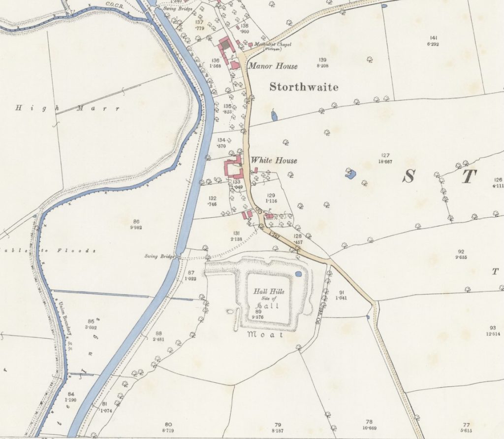
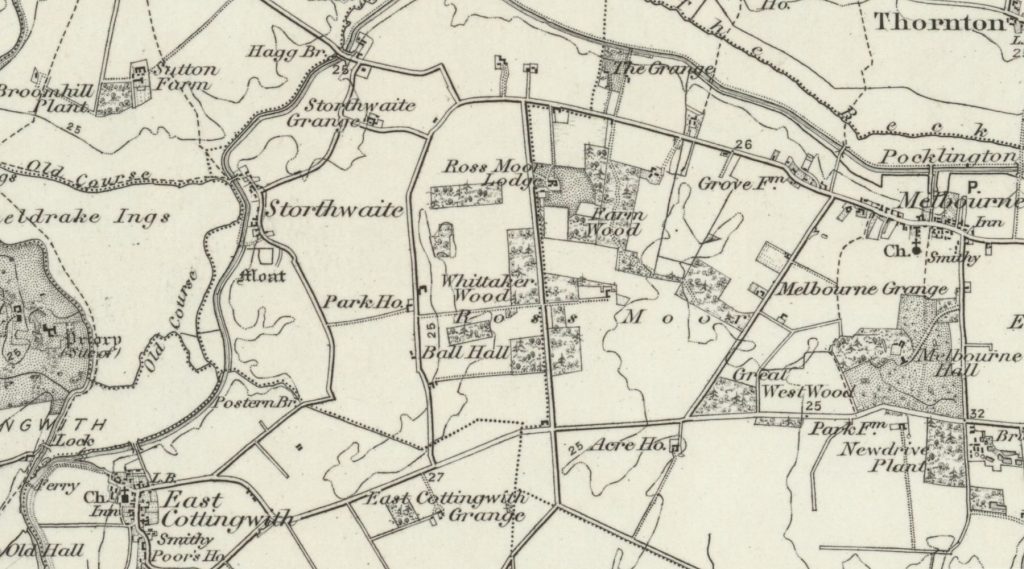
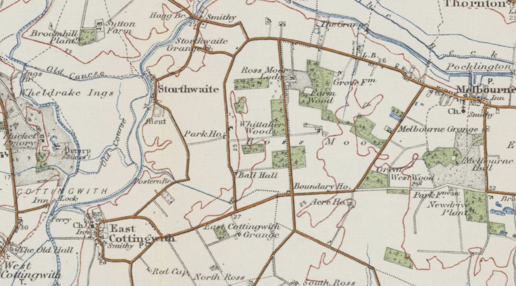
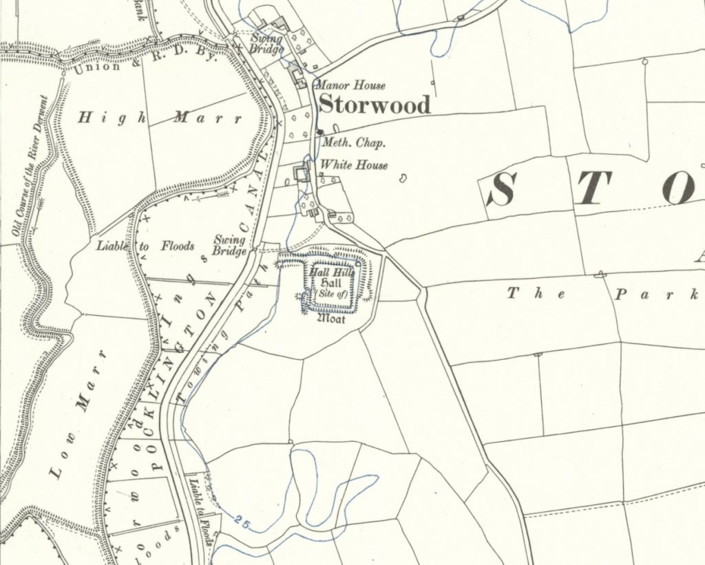
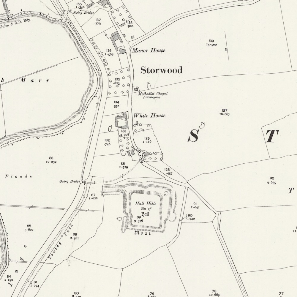
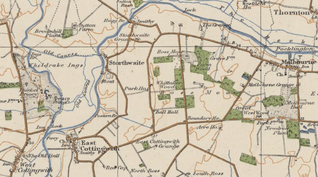
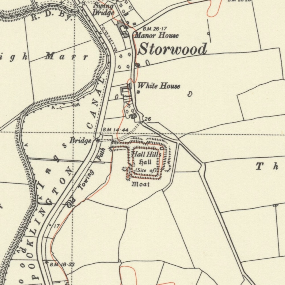
Ordnance Survey Maps
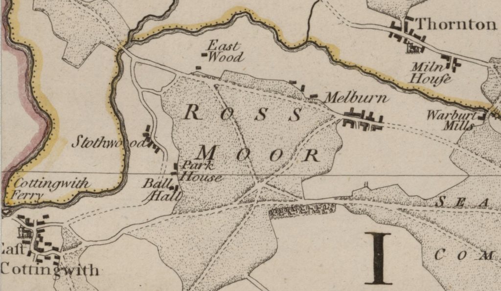
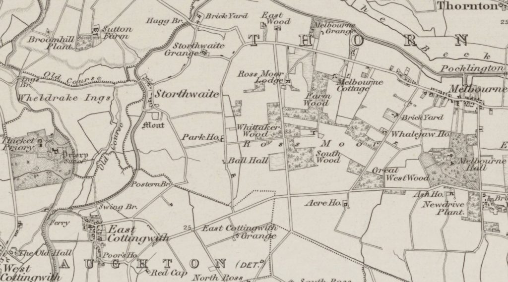
Maps of Storwood over time from the National Library of Scotland, 1771-1952:
Footnotes
- In her will, made on 26 June 1414, Beatrice left £50 for masses to be sung for five years by two chaplains at the church in the shadow of the Roos stronghold of Helmsley, for the souls of herself, Thomas Roos and all the faithful departed, and £40 for the same to be celebrated for four years by a single chaplain at Storthwaite. Brown, S. (2023). Beatrice de Roos (d. 1415) and the Making of Art. Journal of the British Archaeological Association, 176(1), 216–248. ↩︎
- Tom French first established her association with the St William window in York Minster (nVII), in an article that re-dated the window and identified the ‘donor figures’ at its base. Beatrice herself is depicted in panel 1e. Brown, S. (2023). Beatrice de Roos (d. 1415) and the Making of Art. Journal of the British Archaeological Association, 176(1), 216–248. ↩︎
- East Cottingwith, Wikipedia.org ↩︎
- Storwood, Wikipedia.org ↩︎
- Storwood in the wide context of York and Pocklington, Apple Maps ©2026 ↩︎
- The vill of ‘Chetelstorp’, Thornton, A History of the County of York East Riding: Volume 3, Ouse and Derwent Wapentake, and Part of Harthill Wapentake, British History Online ↩︎
- Yorkshire Sheet 192, Surveyed: 1850 to 1851, Published: 1854, Six-inch to one mile, maps.NLS.uk ↩︎
- River Derwent, Yorkshire, Wikipedia.org ↩︎
- Sir Henry Vavasour of Melbourne was a leading promoter of the Pocklington canal, which was constructed in 1816-18, Thornton, A History of the County of York East Riding: Volume 3, Ouse and Derwent Wapentake, and Part of Harthill Wapentake, British History Online ↩︎
- Thorganby – a quick look back in time, Village History, Thorganby Parish Council ↩︎
- Moated site and water-management features south of White House, Storwood, Scheduled Monument, Historic England ↩︎
- Moated site and water-management features south of White House, Official List Entry 1007974, Historic England ↩︎
- Storwood, York, East Riding of Yorkshire, Apple Maps ©2026 ↩︎
- 1844 map of Storwood and Hall Hills by Hobson, William Colling.; J. & C. Walker. maps.NLS.uk ↩︎
- Airbourne Laser Scanning preview – Composite 1m Digital Terrain Model© Environment Agency copyright and/or database right, Enfield Archeological Society ↩︎
- The Barons de Ros Family Tree, Reddit.com ↩︎
- Tenancy in demesne means they gained physical possession of the land, collected its rents, and built their manor house there, Wikipedia.org ↩︎
- Baron de Ros, Premier Baron in the peerage of England, Wikipedia.org ↩︎
- Thornton, A History of the County of York East Riding: Volume 3, Ouse and Derwent Wapentake, and Part of Harthill Wapentake. Originally published by Victoria County History, London, 1976. British History Online ↩︎
- Eddeva aka Edith the Fair (1025-1086), Wikipedia.org ↩︎
- Carucate, Wikipedia.org ↩︎
- Peter de Ros, who was linked with the Mortimers by marriage, gave two carucates of land to St. Mary’s Abbey, York. The Ettons of Gilling ↩︎
- For the King Henry I’s involvement in the conveyance of Goathland hermitage to Whitby Abbey and similar conveyances by other patrons of hermitages at Storwood, Spaldingholme, and Sproxton see
Jane E Burton, ‘Eremitical Tradition’, pp. 29-31. Judith Anne Frost, An Edition of the Nostell Priory Cartulary, London, British Library, Cotton Vespasian E XIX ↩︎ - Warter priory had a hermitage at Storwood in the 12th century. Thornton, HBO ↩︎
- Hermitages, Introductions to Heritage Assets, Historic England ↩︎
- Sir Robert de Ros (1160-1227), Magna Carta Baron, Wikipedia.org ↩︎
- Robert de Ros, Magna Carta links to Pocklington, by Phil Gilbank, Pocklington Post, 2nd July 2015. Pocklington History ↩︎
- William de Ros, Lord of Helmsley, Wikipedia.org ↩︎
- Mesne Lord, Wikipedia.org ↩︎
- Robert de Ros of Helmsley (1237-1285), Wikipedia.org ↩︎
- Turbary, Wikipedia.org ↩︎
- Manors & Other Estates, Hemingbrough: Cliffe with Lund, A History of the County of York East Riding: Volume 3, Ouse and Derwent Wapentake, and Part of Harthill Wapentake. Originally published by Victoria County History, London, 1976. British History Online ↩︎
- William Ros (1285-1343), 2nd Baron Ros of Helmsley, Wikipedia.org ↩︎
- Margery De Ros née Badlesmere (1304-1363), FindaGrave.com ↩︎
- Thomas Ros (1335-1384), 4th Baron Ros of Helmsley, Wikipedia.org ↩︎
- John Ros (?-1393), 5th Baron Ros of Helmsley, Wikipedia.org ↩︎
- William Ros, 6th Baron Ros (1370-1414) inherited his father’s feudal barony and estates, Wikipedia.org ↩︎
- King Richard III (1452-1485) Wikipedia.org ↩︎
- King Edward IV (1442-1483) Wikipedia.org ↩︎
- Thomas Ros or Roos (1427-1464), 9th Baron Ros of Helmsley, Wikipedia.org ↩︎
- After Thomas, Lord Ros’s attainder in 1461 the manor was granted for life to Ralph, Lord Greystoke, in 1468. Thornton, British History Online ↩︎
- Ralph Greystoke (1406-1487), 5th Baron Greystoke, Wikipedia.org ↩︎
- Thomas Ros or Roos (1406-1430), 8th Baron Ros of Helmsley, Wikipedia.org ↩︎
- Richard Ros, 2nd son of Thomas Ros, 8th Baron Ros, married Joan Knyvett, Wikipedia.org ↩︎
- Thomas Ros or Roos (1427-1464), 9th Baron Ros of Helmsley, Wikipedia.org ↩︎
- Edmund Ros or Roos (1455-1508), 10th Baron Ros of Helmsley, Wikipedia.org ↩︎
- Edmund’s sister Eleanor married Sir Robert Manners and at Edmund’s death in 1508 the manor passed to her son Sir George Manners. Thornton, BHO ↩︎
- George Manners (1470-1513), 11th Baron de Ros of Helmsley, Wikipedia.org ↩︎
- The manor was worth £55 a year in the mid 16th century. Thornton, BHO ↩︎
- Ale-Tasters, Wiktionary ↩︎
- Thomas Manners (1497-1543), 1st Earl of Rutland, 12th Baron Ros, Wikipedia.org ↩︎
- Henry Manners (1526-1563), 2nd Earl of Rutland, 13th Baron de Ros of Helmsley, Wikipedia.org ↩︎
- Edward Manners (1549-1587), 3rd Earl of Rutland, 14th Baron de Ros of Helmsley, Wikipedia.org ↩︎
- Elizabeth Cecil, née Manners, 15th Baroness Ros, Wikipedia.org ↩︎
- William Cecil, 16th Baron Ros of Helmsley, Wikipedia.org ↩︎
- In 1639 John Bradley was living at Storwood, though apparently not in the manor-house. Thornton, BHO ↩︎
- 1771 The County of York, by Jefferys, Thomas, maps.NLS.uk ↩︎
- 1862 Sheet XCIII SE York, England and Wales, One-inch to the mile, Old Series, 1801-1869, maps.NLS.uk ↩︎
- 1892 Yorkshire CXCII.11, OS 25 inch England and Wales, 1841-1952, maps.NLS.uk ↩︎
- 1898 Sheet 71 – Selby, One-Inch, England and Wales, 1872-1914, maps.NLS.uk ↩︎
- 1908 Sheet 27 – York, One-inch England and Wales, 3rd ed., Large Sheet Series, 1906-1917, maps.NLS.uk ↩︎
- 1910 Yorkshire CXCII.SE OS Six-inch England and Wales, 1842-1952, maps.NLS.uk ↩︎
- 1910 Yorkshire CXCII.11 OS 25 inch England and Wales, 1841-1952, maps.NLS.uk ↩︎
- 1919 York District (District map) One-inch “Popular” edition, England and Wales, 1919-1926, maps.NLS.uk ↩︎
- 1952 Yorkshire Sheet CXCII.SE OS Six-inch England and Wales, 1842-1952, maps.NLS.uk ↩︎
References
- GB Historical GIS / University of Portsmouth, History of Storwood, in East Riding of Yorkshire and East Riding | Map and description, A Vision of Britain through Time
- A P Baggs, G H R Kent, J D Purdy, ‘Thornton’, in A History of the County of York East Riding: Volume 3, Ouse and Derwent Wapentake, and Part of Harthill Wapentake, ed. K J Allison (London, 1976), British History Online
- A P Baggs, G H R Kent, J D Purdy, ‘Harthill Wapentake’, in A History of the County of York East Riding: Volume 3, Ouse and Derwent Wapentake, and Part of Harthill Wapentake, ed. K J Allison (London, 1976), British History Online
- Magna Carta baron, Robert de Ros, Manor House at Storwood, Pocklington History
- ‘Hall Hills Hall’ Earthworks of Ros Manor-House, Storwood, Gatehouse
- 1396 Bridge over River Derwent at Sutton upon Derwent, Yorkshire, Wikipedia.org
- Hagg Bridge, Grade II Listed Building, Historic England
- Pocklington Canal, Wikipedia
- 1840 -1909 Directory Entries, Storwood, Pocklington History
- A short history of the parish, East Cottingwith & Storwood Council, East Cottingwith Parish Council
- A short history of the parish, East Cottingwith & Storwood Council, East Cottingwith PC.Gov
- Storwood Grange, Grade II Listed Building, Historic England
- Chetelstorp, Open Domesday.org
- Moated site and water-management features south of White House, Storwood, Scheduled Monument, Historic England
- The County of York, surveyed in 1767, Thomas Jefferys, Maps.NLS.uk
- Greenwood, C., Bingley, J., Teesdale, H., Map of Yorkshire, 1828, Maps.NLS.uk
- Map of Storwood, East Riding of Yorkshire, c1900, maps.NLS.uk
- Medieval moated site surviving as an earthwork, possibly the site of the fortified manor house, Monument Number 59509, Historic England Research Records, Heritage Gateway
- Maps of the East Riding of Yorkshire 1673-1898, Hull History Center
- Monument record MYO5112 – River Derwent Navigation, York Historic Environment Record
- Effigy of Robert de Ros, Plaster cast of a tomb effigy of an unknown knight (probably William from the de Ros family) with the de Ros coat of arms on the shield, V&A
- Robert de Ros – 1st Lord Ros of Helmsley, Great Castles
- Monument No. 23829 Moated site and water-management features South of White House, Grid Ref. 7121 4392, Conservation Area Appraisal, East Cottingwith, East Riding of Yorkshire